The Bidwell House, Part I: “Number Won", "Green Woods", "Lowdontown" and "Hushens”
Why hold this event in an area of western Massachusetts described by one of the Convention Army in October of 1777 as where “We marched in a desolate mountain range…”, rather than a famous site such as Lexington, Concord, Bennington or Saratoga? [1] First off, each of those sites hosts events from time to time as well. The Bidwell House, located in what was at that time southern Hampshire County, Massachusetts, also offers participants and visitors a setting steeped in 18th century history. The area saw soldiers coming and going throughout the war. Some traveled in small parties or even alone, while others were with larger or better known groups, such as the passage of Colonel Henry Knox and his train of artillery, bound for Cambridge in the winter of 1775-1776, and the German column of the Convention Army in 1777.
A section of the “Old Post Road” is shown as crossing the Bidwell House grounds on its hiking trails map. If so, what was once a main route of travel is no longer that now. Tracing the roads of the eighteenth century presents a number of challenges. Road builders in 1777 bypassed obstacles such as swamps that today can be relatively easily bridged with fill and culverts, or sections of hillside too steep to climb and difficult to cut into, leading to later road changes and more direct travel routes.
The town of Monterey, where the Bidwell House is located, didn’t exist in 1777. In western Massachusetts the names and boundaries of towns, and even counties, have changed significantly over time. Private Joshua Pillsbury of Dracut returned home from Saratoga in October of 1777 with Colonel Jonathan Reed’s Massachusetts Militia regiment “... as a guard to the Hushens”, Hessians he intended, though most of the captured Germans were Brunswickers. His account is brief, but tracks their route, and illustrates how place names have changed. After leaving Great Barrington he lists his stop that evening as being in “Number Won” (an earlier name for Tyringham), followed by a march “through the greenwoods Lowden and Glasgo mountain to Westfield”, twenty-seven miles in all, the following day. [2]
Almanacs are a good starting point for understanding what was where. Samuel Stearns “The North American’s Almanack” published in 1776 contains four pages of tables entitled “ROADS to the principal Towns on the Continent, &c. from BOSTON; With the names of those who keep houses of entertainment.” Table XIX lists stops along the road from Springfield to Albany by way of Blandford, “Greenwood” (the site of Rowley and Spring’s taverns), Tyringham where Chadwick’s tavern was, and Great Barrington.
Colonel Jeduthan Baldwin, an engineer in the Continental Army, would return home from Albany, New York to Brookfield, Massachusetts in November of 1777. After staying in Nobletown (then considered by some part of Massachusetts, but today Hillsdale, New York) the night of the 14th, he would ride as far as what he called “Lowdontown” on the 15th, and reach Springfield on the 16th - covering some fifty miles in just two days. [3]
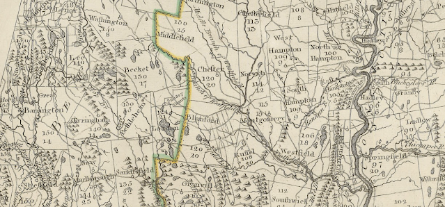
A section from the first detailed map of Massachusetts created in 1798 is a snapshot of these changes and some of the roads through the area. Less than ten years after the Revolutionary War, the town Russell had been created between Blandford and Westfield. The area residents and travelers referred to as “Greenwood” or “Green Woods” had been organized into Bethlehem and Loudon (Baldwin’s “Lowdontown”), today’s Otis incorporated in 1810, and in 1847 the southern section of Tyringham would become Monterey. Pillsbury’s “Glasgo” is actually a reference to “Glasgow”, as what became the town of Blandford was called by its early Scottish settlers.
Finding and getting to the Bidwell House is far easier today than it was in 1777. Route 23 runs between Great Barrington and Blandford, and a turn to the north in Monterey on Tyringham Road leads to the intriguingly named “Art School Road” and the Bidwell House - but sorting out the story behind that road name may be too far afield from our focus. Google Maps even offers a “Copy Plus Code” feature that allows for the sharing of a specific location such as the Bidwell House: “6Q5J+9M Monterey, Massachusetts” Paste it into the search bar, and it brings you down to street level, with your choice of a map view, terrain overlay or satellite imagery. All are a far cry from the hand drawn maps of the 18th century, such as Carington Bowles 1776 “Map Of The Seat Of War In New England” available on the Library of Congress website. Seen in part below showing southwestern Massachusetts, only Blandford and Westfield are marked of the towns mentioned above, along with several of the numbered "Houfatomik" townships.
Next Week: The Bidwell House, Part II: “One Of Our Geniuses Had Been Bundling All Night”


Comments
Post a Comment