Brookfield, Continued - "The Furthest Part"
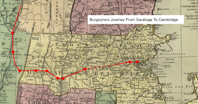
Lieutenant Israel Bartlett, a Massachusetts Militia officer escorting the British column of the Convention Army, noted that on October 31st he and his comrades "... marched 1 1/2 mile [from present-day Warren, Massachusetts] and halted in front of the British Army - breakfasted & marched to the furthest part of Brookfield 11 miles from our last quarters. We were forced to march 4 or 5 miles further than we intended, for want of quarters." [1]
What was Brookfield in 1777 is now four towns: Brookfield, North Brookfield (incorporated in 1812), West Brookfield (incorporated in 1848, but as the site of the first area of European settlement claimant of the title of the "mother town" of the Brookfields), and East Brookfield (incorporated in 1920, and the youngest town in Massachusetts). The present day borders of these towns span a straight-line distance of about ten miles both west to east and north to south.
The European settlement of the Brookfield area was perhaps the result of one of the earliest anti-immigrant policies in America, according to YouTube historian Andrew Rakick's Atun-Shei Films video "America's First Conspiracy". Despite the egalitarian beginning of the Massachusetts Bay colony, by the middle of the 1600's wealth had begun to concentrate into the hands of a few families. The need for land, in particular for raising cattle, had led to westward expansion. It also led Ipswich town leaders to pass an ordnance prohibiting anyone who did not own a home in the town from using common land for grazing livestock. As a result, poorer and newly arrived settlers would need to risk the danger and hardships of life on the frontier for the chance to get ahead. In 1660 what was called "Quaboag Plantation" was deeded by the Massachusetts legislature to the leading citizens of Ipswich, just north of Cape Ann on the Massachusetts coast. Brookfield was chosen it appears, because the Nipmuck people had for some time kept the land open by the annual burning of the meadowland. [2]
The expanded settlement of Massachusetts in the 17th century created resentment in the Native population who saw their lands being taken, and colonial rule imposed on their people. In 1675 this resentment erupted into violence, in what became known as "King Phillips War" as Native warriors sought to reclaim tribal lands. In Brookfield, Nipmuc warriors ambushed a company of Massachusetts militia in what has become known as "Wheeler's Surprise", followed by the "Siege of Brookfield" at John Ayers garrison house, the site of which is marked on present-day Foster Hill Road, West Brookfield.

Fighting began on August 1, 1675 when an armed party under Captain Thomas Wheeler of Concord, sent by the Governor of Massachusetts to urge the Nipmuc tribe to remain neutral was instead ambushed and eight were killed. Those who were able to escape retreated to Ayers home, where until August 5th they and the inhabitants of Brookfield held off repeated attacks. One, settler, Samuel Pritchard, was captured when he left the garrison house. Survivors recalled his captors "... cut off his head, kicking it about like a foot-ball, and then putting it upon pole, they set it up before the door of his father's house in our sight." [3] In October the town was abandoned, and not resettled until 1686.
A century later the Convention Army would follow the path of the upper post road past what is now the West Brookfield Common. Exactly how British and German troops entered Brookfield is somewhat unclear. Likely they were unaware of the conflict which preceded their passage through the area.
Today, just before the center of West Brookfield on Route 9, one encounters a good source for used books of all types, the Quaboag Book Shop, and in the center of town the recently re-opened Hitchcock Tavern, which operated for several years recently as "Ye Olde Tavern", before bearing left onto Foster Hill Road and past the marker commemorating John Ayers death.
Foster Hill Road re-joins Route 9, just west of the Brookfield Cemetery, the site of Joshua Spooner's grave. After just under a mile, the original post road splits off again to the left onto Route 148, then to the right onto Brookfield's East Main Street, past the site of Spooner's home, its well marked to commemorate his murder, several milestones, another "massacre" site dating from 1693, and a marker to Waite's tavern. In doing so it bypasses a mile long section of Route 9 in East Brookfield which is perfectly straight, a clear indication of a modern roadway in New England. Where exactly Bartlett and his prisoners stopped in the "furthest part of Brookfield" appears lost to history.


Comments
Post a Comment