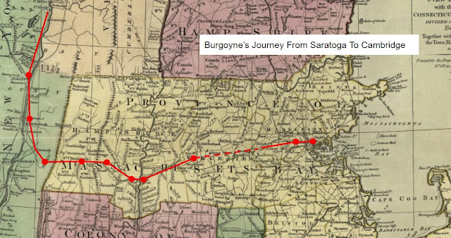
Where The Germans Went - "Continued On Through Spencertown"
After leaving Kinderhook and passing through Claverack on October 24th, one German account of the march noted: "We continued the march through Spencertown, a village not very much built up, whose houses are widely separated from each other. It is inhabited by Northern Germans but is the last place having all German inhabitants. We went on hilly and stony roads today and after 17 Engl. miles we reached Nobletown..." [1] A second account likewise notes a seventeen mile march from Kinderhook through Claverack to Nobletown, but is silent as to how they got there. [2]
Massachusetts militiaman Joshua Pillsbury, a guard with the column, recorded that he marched of twenty-two miles on the 24th, and stopped in "Egremont N.E. [New England?] Massac[husetts]", just west of Great Barrington. [3] Brunswicker Grenadier Johann Bense, marching and stopping where he was told no doubt, simply noted that on the night of the 24th he stayed "at an unknown place in the woods." [4]
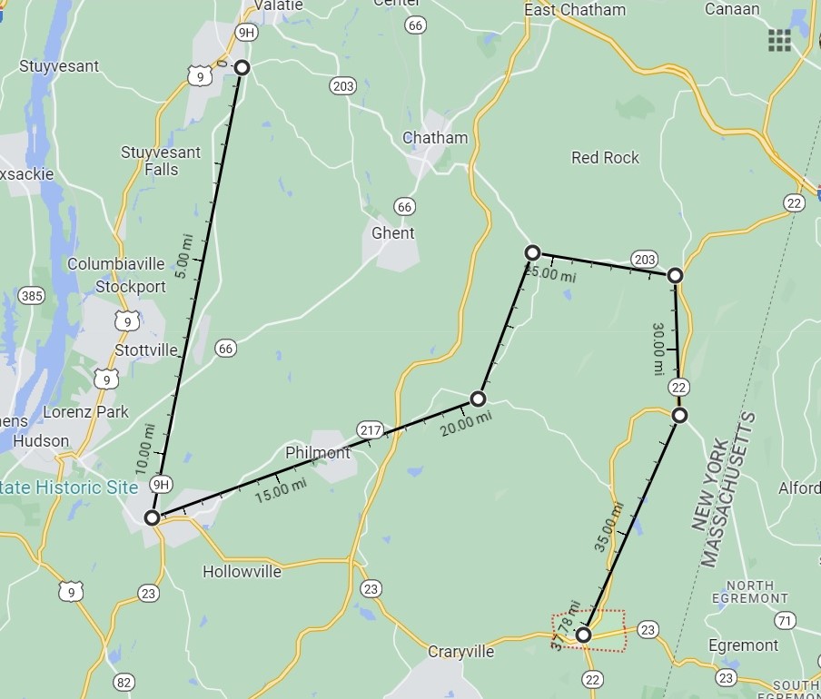
If the German column didn't take this round-about route, how did they get to Nobletown? Likely, their march from Kinderhook went to the southeast through the region known as Claverack, rather than the town today, perhaps through what is now the village of Ghent. It's also likely that they passed through a section of Spencertown, rather than marching up to the present-day village center, and then back down to Nobletown.
Using mileage to establish where the column went on a particular day is a challenge. In Brookfield, Massachusetts, for example, some of the prisoners would spend one night camped in "the furthest part" of town, rather than the center. Mileage table XIX in Samuel Stearns' "The North American's Almanack" for 1776 further illustrates this challenge. Three inns are listed as being located in Nobletown, with McKinstry's being three miles beyond Cowles, and Ray's three miles beyond McKinstry's, giving what was considered Nobletown a length of six miles at a minimum. In Kinderhook, four inns are listed, spaced at least seventeen miles apart. One traveling between one of the inns in Nobletown to one in Kinderhook could travel a distance ranging from six to thirty-one miles. Neither Claverack or Spencertown is listed as the site of an inn along the road to Albany, but "Hogeboom's" is listed as being in "Stonehouse", four miles from the last in Nobletown inn and two from the first in Kinderhook.
A second argument for a more direct route can be based on the placement of markers to commemorate the route taken by Colonel Henry Knox in the winter of 1775-1776, to transport captured British artillery from the Champlain Valley to American forces laying siege to the town of Boston. The Knox Trail markers in New York start at Crown Point on Lake Champlain, and run all the way to Massachusetts border. Number 26 is the first in Kinderhook, followed by numbers 27 and 28 in what now is the town of Ghent, then number 29 in Hillsdale. When plotted on a map, the distance between them is about seventeen miles - the same as recorded by the German column.

Today Saint Peters is located on the west side of Route 203, but the on-line church history indicates that the building was dismantled and moved there from across the street in 1826. St. Peters was likely not where the German column received its blessing for their journey, as it was neither Lutheran or German, as it was organized by settlers from Connecticut in 1750.
Regardless of the route that was taken, October 24th would be their last night in the state of New York, unless they had already entered Massachusetts - but we'll need to wait an extra week to try to get to that. Next week instead, we'll look at a Convention Army connection with the tea protests of 1773 and 1774.

Comments
Post a Comment