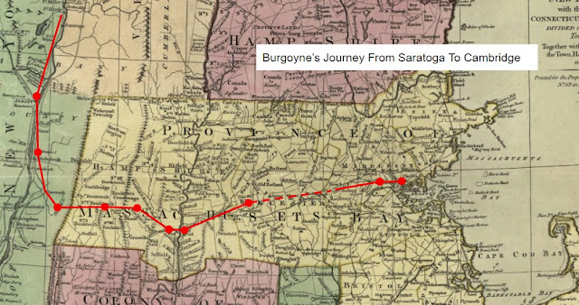
What The Convention Army Saw - "To Delight The Eye"
The prisoners of the Convention Army traveled through a region most had likely heard about, but never seen. Their march from the Saratoga battlefield in the fall of 1777 took them through Hudson Valley villages settled by Dutch and German farmers, isolated hamlets in the Berkshires which had sprung up beyond prosperous English settlements along the Connecticut River, and the towns of Worcester and Middlesex Counties which marked a century and a half of expansion from the settlement of Boston in 1630; all land occupied by a Native population for countless generations before the arrival of Europeans.

What did they see? Most obvious was the terrain: two major rivers and two mountain ranges before reaching the hills of central Massachusetts, and then their barracks overlooking Boston Harbor.
A painting in the collection of the Worcester Art Museum, "Looking East From Denny Hill" seen in an image © Worcester Art Museum, offers a glimpse of the countryside as seen from Leicester, Massachusetts, albeit in 1800.
The painting, done by Ralph Earl, captures a settled agricultural landscape in the hill towns of central Massachusetts. It may reflect his fondness for the area where he once lived, or more likely the fondness of Colonel Thomas Denny Jr., who commissioned the painting when he moved from his home in Leicester on the hill that still bears his family name. [1]
In Earl's painting, farmers work their fields, and the winding road along which the Convention Army marched runs east to Worcester. The white steeples of several meetinghouses mark the town, where on the night of November 4, 1777, a regiment of German troops slept in one, that though it had"... only been constructed with wood, it must be considered beautiful in its own way". [2] Here and there in the painting are homes, scattered woodlots, and fences or perhaps stone walls separating fields. Soldiers from the 47th Regiment of Foot, who fought their way back to Boston from Lexington and Concord on April 19th, 1775, and now marched through Massachusetts as prisoners, would remember New England stone walls as being "... almost to the height of their shoulders". [3]
Corporal Roger Lamb, of the British 9th Regiment of Foot, saw nothing "to delight the eye" until halfway through his journey, when he arrived in Hadley, Massachusetts. Lamb's recollection of the start of the march was: "The way before and about us presented an uncheering appearance; mountainous and barren, with little of pleasing scenery to amuse the traveller." Perhaps though his view was jaded, given his impression of the inhabitants, of which he said: "The people of New England appeared to indulge a deadly hatred against the British prisoners, and rejoiced at any occasion to gratify it." [4]
British Ensign Thomas Anburey shared Lamb's opinion that there was little pleasant to see on the early part of their journey. A few days after setting out he recalled they "were two days in crossing the Green Mountains... the roads across them were almost impassible..." and, that the night before he arrived in Williamstown he was "... quartered at a small log-hut." [5]
Things looked better to the Germans as well as the British as they neared the Connecticut River. In Blandford, they saw "... many well built houses, a delight for the eyes." One also noted: "You cannot find more beautiful cattle than in this region and it is true that you see here oxen of 1,700 to 1,800 pounds and pigs weighing 500 pounds." East Springfield, now simply Springfield, was: "... much bigger and more beautiful" than West Springfield, with "exquisite" houses whose gardens bordered the street "with beautiful palings [picket fences] and are at times also adorned with statues." Leaving Springfield one noted: "Here we discovered beautiful roads...", and though not visible in Earl's painting, "... every mile, a stone indicator marking the number of miles to Boston." [6]

Throughout their march, Lieutenant-General John Burgoyne and his soldiers saw people as well as buildings and places. Some were hostile. In Great Barrington, though the houses were "quite solid and well built... You cannot imagine any people more mean and malicious than the individuals here." In other towns, people were more friendly, or at least in Westfield "moved by pity and compassion", and willing to allow freezing soldiers into their homes to get out of the rain, snow and hail that night. [7]
The observations of the Convention Army reflect an awareness of the diversity of the people who occupied the region, and perhaps a bit of bias. A German officer noted that in passing from New York into Massachusetts: "From now on, we came to places whose inhabitants were of Engl.[ish] origin. The fields are not worked as well as with the Dutch but the German colonists [who were settled in prior town, Claverack, New York] also surpass the latter in this regard. The Germans plant all types of grain, the Dutch plant little rye and the English limit themselves almost exclusively to wheat, maize [corn] and some oats. In regard to garden fruit, it is the same and you find the best at the Franks." [8]
Some of what they saw helped them to better understand how it was they had come to be defeated. Ensign Anburey noted "On our march to this place [confinement in Cambridge and Charlestown], we were fully convinced what powerful levies the New England states are capable of furnishing..." Every town they passed through had sent men from their militia to fight at Saratoga, was raising two or three companies to join the Continental Army, and had families who would donate a blanket, even if they only had two, to support “... that idol, Independency”. [9]

Comments
Post a Comment