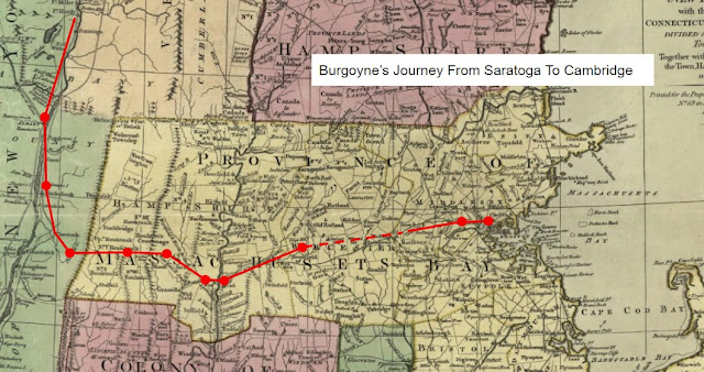
West Springfield, Massachusetts - “The Roads Were Golden”
On October 29, 1777, the German column of the Convention Army marched seven miles. The bad weather continued; more rain, accompanied by snow and ice, but it was less windy than the day before. The roads improved, one German officer noting they "... were golden in comparison to the earlier ones”, or at least "no longer abominable”. [1] The Berkshire mountains were now behind them. Their march east from Westfield, Massachusetts, took them to West Springfield, on the west bank of the Connecticut River; flat, fertile farmland settled by Europeans over a century earlier, and occupied by Native people for countless generations before that.
 When the German column stopped for the night, several noted that the people there "... took us into their houses", though it was “in spite of the residents aversion to receiving us”. [2] Once again it appears likely that the Brunswick Grenadier Johann Bense was assigned quarters in a building of some sort as well, as he didn't mention being "in the woods" on either of the two days he was there.
 West Springfield was described by the Germans as "... a village or town with scattered houses and a church of its own...". [6] The church the Germans saw, or "meeting house" as New Englanders would say, and Montresor marked on his map, was built in 1702 and expanded twice, but demolished around 1820.

Bense wrote that he arrived "in Springfield" on the 29th. He was in actually in West Springfield, as two days later he would note that he crossed over the Connecticut River. [3] Other German sources confirm their arrival in West Springfield on the 29th, noting of the town: "... the Connecticut [River] separates it from East Springfield." [4]
West Springfield had been a part of Springfield for over a century. In 1698 it was established as a separate parish, which allowed residents there to have their own meeting house on their side of the river. In 1774 West Springfield was incorporated as a separate town, and by 1776 it had a population of 1,744 residents. [5] It's not surprising that Bense referred to the newly incorporated town simply as Springfield. A map of New York and the western part of New England drawn by the British engineer Captain John Montresor in 1775, which was "Republished, with great Improvement, April 1st, 1777", does the same, as seen in the close-up below.

One of the houses the Germans most likely saw, and perhaps some even stayed in, was what is now known as the Josiah Day House. The Day house is a building that is common in one way and rare in another. As seen in the first photo above, its form is what is commonly referred to as a "salt-box" style house. Homes of this nature, two stories, with a center chimney, and a slopping back roof, were fairly common in Massachusetts at the time of the Revolution. The Day house however was built of brick rather than wood. Brick building were less common in Massachusetts outside of Boston at this time, and brick saltbox homes even less so.
Up until now it's been a challenge for me to determine what period buildings still exist in the towns along the 1777 route of march of the Convention Army. That changed - for Massachusetts at least - when I learned about a free on-line database available through the Commonwealth of Massachusetts Historical Commission, the "Massachusetts Cultural Resource Information System" ("MACRIS"). A search of the database for historic properties in West Springfield dating from 1777 or earlier resulted in nine potential matches. Five of these were excluded, as they were either too far off the likely route of the Convention Army or moved into town early in the twentieth century to create the "Storrowtown Village Museum".
Of what remained, including the Day House, the other houses the Germans may have seen are the Samuel Ely house at 431 Elm Street, believed to have been built around 1763; and possibly the Stebbins-Colton house at 10 King's Highway, built around 1756, depending on how they marched through town and how spread out their quarters were in town. While West Springfield's 1702 meeting house has been gone for over two hundred years, undoubtably many of the Germans saw the town's first burying ground which was nearby, now the "Cold Spring" or Union Street Cemetery at the corner of Church and Union streets.
While the Ely and Stebbins-Colton houses are private homes, and not open to the public, the Josiah Day house is owned and operated by the Ramapogue Historical Society as the Josiah Day House Museum, and open to the public seasonally by appointment and for special events.
I was fortunate to learn MACRIS during a Springfield Preservation Trust presentation on colonial homes in Springfield, Massachusetts, by Derek Strahan. The Josiah Day House is only one of the many buildings on his "Lost New England" website, which is well worth taking a look at.
As to Johann Bense and his comrades, they likely welcomed the news that they would spend two nights in West Springfield, to rest and to draw provisions before crossing the Connecticut River on October 31st. I'll have a bit more to say about that next week, including something I hadn't noticed on a prior visit to West Springfield.
[1] Specht Journal, 107. Letters From America, 123.
[2] Letters From America, 123. Specht Journal, 107.
[3] Bense, 77-78.
[4] Letters From America, 123.
[5] Massachusetts Historical Commission, Reconnaissance Survey Town Report West Springfield (Boston, MA: 1982), 1, 5-7.
[6] Letters From America, 123.
For more on the Convention Army's 1777 march from Saratoga to Boston, see:

Comments
Post a Comment