Commemorating The Convention Army's Journey - “Only A Short March To Worcester”
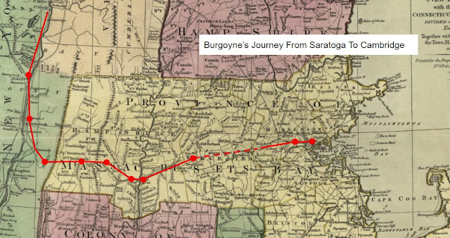
I've walked short sections of the Convention Army's route of march from Saratoga to Cambridge in the past. My favorite, so far, runs for a mile or so from the Joshua Spooner well marker on East Main Street in Brookfield, and then along Slab City Road in North Brookfield. This year I decided to commemorate the Convention Army's 1777 journey by, among other things, walking an entire day's march on its anniversary date.

It's also relatively short, about six miles, compared to more than half of the marches the German column made which were ten miles or longer - and it is significantly shorter than the eighteen mile long march much of the British column made on November 2nd from Brookfield through Leicester into Worcester. As one German officer noted: “The 4th, we had only a short march to Worcester...”. [1]
While we don't know exactly where the German column of the Convention Army stayed in Leicester, is possible that it was on and around the town common. My hike began there, where I noted several reminders of the the town's colonial past, including a boulder with a bronze plaque pictured above dedicated "In Memory of the Minute Men and Standing Company Who Marched From This Spot on the Alarm of April 19, 1775..."; a slate marker noting "Washington Passed This Way 1 July 1775 On His Route To Cambridge To Take Command Of The Patriot Army"; as well as a red sandstone post road mile marker said to be located "54 Mile From Boston" (followed by markers 53 and 52, further along Main Street to the east); and a granite block engraved "On This Lot First Church Erected 1719 And First School House 1738".
Today Leicester's common is set off from the main east-west roadway through town, Route 9, just after it intersects with Route 56, if one is traveling west to east as the Convention Army did. I'm not aware of any map of Leicester that dates from 1777 that shows which roads went where in town at that time. It's changes like this which make finding and following the actual route of march a challenge.

The march from the Leicester town common into Worcester starts off with a short down-hill stretch before the road rises just east of its intersection with Henshaw Street. After that short climb, the next three and a half miles of the march is pretty much downhill or level, with the exception of a slight rise after Beaver Brook in Worcester, after which the remaining mile and a half or so was along a fairly straight road with a slight downhill slope. One suspects that the November 4th march made by the German column was not only short, but relatively easy compared to crossing the Berkshires during a winter storm, or the seventeen miles they marched on October 24th from Kinderhook to Nobletown before stopping for the night.
Next Week: Maps - “Sitting In Their Closets, With A Map Before Them”
Last Week: Burgoyne’s Camp Kettle - “Captured October 17, 1777, In The Battle Of Saratoga[?]”
For more on the Convention Army's 1777 march from Saratoga to Boston, see:
1777 March Blog Home Overnight Stopping Points Towns and Villages Along the Way
General Whipple's Journal Burgoyne in Albany Annotated Bibliography
[1] Pettingill, Letters From America, 125.


Comments
Post a Comment