Saratoga to Boston 1777 - "The Easiest, Most Expeditious, and Convenient Route"
Article IV of the Articles of Convention required "The army under Lieutenant-general Burgoyne, to march to Massachusetts Bay, by the easiest, most expeditious, and convenient route; and be quartered in, near, or as convenient as possible to Boston..."
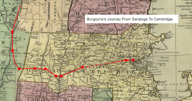
Understanding the routes taken is a study of history and geography. There is no direct natural route from Saratoga to Boston, but a well established network of roads provided a way across rivers and streams, over mountains, through woods, and past countless farms and villages. American militia units had taken many of these roads in the summer and early fall of 1777 to join the Northern Army under Major-General Horatio Gates at Saratoga, and would use them to escort Lieutenant-General John Burgoyne's British and German troops to quarters in Cambridge and present-day Somerville (then part of Charlestown) Massachusetts to await their fate. I'm interested in following their footsteps as closely as possible.

The Convention Army's journey into captivity began in the town of Stillwater, New York, located on the west bank of the Hudson River, across from its meeting point with the Hoosic River. Burgoyne's army anticipated a difficult journey. Lieutenant William Digby of the British 53rd Regiment of Foot noted the day before the surrender: "In the mean time, we made preparations for so long a march - about 200 miles and the wet, rainy season just coming on. I had not destroyed all my baggage, tho' indeed most of it was gone at the general conflagration; but as to horses who outlived our late scene of every imaginable distress, they exhibited a most wretched picture of poverty and want, made up of nothing but skin and bone, and it may naturally be supposed, rather unfit for such a journey." [1]
Once across the Hudson, British and German forces traveled the road to Schaghticoke, New York. From there, Brigadier-General John Glover, tasked by Gates to get the Convention Army to Massachusetts, had ordered that "... for the better supplying of which & the conveniency of the Inhabitants of the country through which they marched, I divided them into two Divisions; the British by Williamstown and Northampton; the Germans by Kinderhook and Springfield..." This was necessary, he informed officials in Massachusetts, as "... the number of Prisoners, Drivers of waggons, Bat-horse-men & the Guards, are at least 6,000, I am put to great difficulty to find provisions for them." [2]

British Corporal Roger Lamb of the 9th Regiment of Foot would recount in memoirs he published after the war: "We were marched during the rigors of winter, in a cold climate, two hundred miles from Saratoga to Boston..." and "From the outset of our marching we experienced much hardship, sleeping in barns, and having but bad clothing, and scanty provisions..." [3]
A list of stopping points in a copy of a journal kept by an unidentified officer of the British 47th Regiment of Foot lists a stop in "Westbury" - likely Westborough, Massachusetts on what appears to be an offshoot from the main line of march.
German troops would head south through the Hudson River Valley towns of "New City" (now a part of Troy), Greenbush and Kinderhook, New York, then east over the Taconic Mountains to "Nobletown, Massachusetts" (now Hillsdale, New York) and Great Barrington, Massachusetts. They too would cross the Berkshires, but be ferried across the Connecticut River at West Springfield. Bense would note October 28th as a particularly trying day, when they experienced "... again a very wretched march in rain and snow on an impossible road through Westfield. We were quartered 5 miles beyond Westfield. One man from the Grenadiers froze to death." [4] From Springfield they would follow the Post Road to Palmer and through the Quabaog River Valley to "Western" (present-day Warren). Like their British comrades a day or so ahead, they would continue on from Brookfield to Cambridge and captivity.
Now, each section of the route and each town along the way is an opportunity for discovering history and more. Overall, markers directly related to the march of the Convention Army are rare, but there is a plaque for the "Hessian Camp" on the common in West Springfield - a topic for another post. What's more, just a few steps away is a wonderful Italian market, the Calabrese Market, at 54 Park Street. Unlike Corporal Lamb's "scanty provisions", we enjoyed arancine (fried rice balls), hot panini sandwiches, cannolis and lemon mascarpone cake.
Next week: Surrender at Saratoga - "The Greatest Conquest Ever Known"
For more on the Convention Army's 1777 march from Saratoga to Boston, see:
1777 March Blog Home Overnight Stopping Points Towns and Villages Along the Way

Comments
Post a Comment